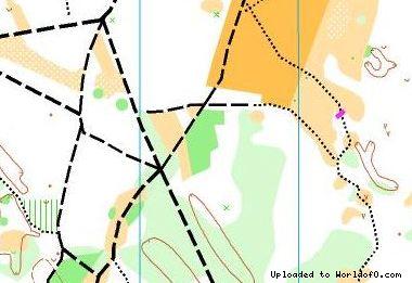
Orienteering Map Dravski park Varaždin (MTBO)
19/11/2013: Due to changes with Google Maps currently no outline is shown for maps! Please let me know on jan@kocbach.net if this is an important functionality for you.
Rate this map!
Map name Dravski park Varaždin (MTBO) Owner/Club OK Međimurje Country Croatia Year 2007 Scale 1:10 000 / 1: 5000 Contours (meters) 5 Area (sqkm.) 2 km2 Nearest place or city Varaždin Region Varaždinska Županija Email address for ordering
no javascript, no e-mail! Owner webpage (url) Link Accessability (free access or need permission?) need permision Map type MTB-O map Map makers (fieldwork, drawing, etc.) Vladimir Tkalec Price per map (euro) 2 Contact details for ordering/questions send us mail Terrain description Urban park area, path network Comments about the map Brand new map, used one times for Croatian and Slovenian national championship in MTBO sprint in 2007. Image at other webpage (url to jpg/gif/png) Link Source (Source ID: ) Images (click for larger) Add/change info Click here
Access denied for user 'worldof_news'@'217.170.198.18' (using password: YES)