Orienteering Map Varaždinske Toplice 2
19/11/2013: Due to changes with Google Maps currently no outline is shown for maps! Please let me know on jan@kocbach.net if this is an important functionality for you.
Rate this map!
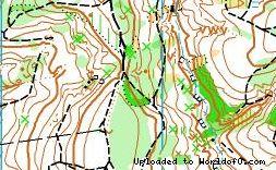
Map name Varaždinske Toplice 2 Owner/Club OK Međimurje Country Croatia Year 2007 Scale 1: 10000 Contours (meters) 5 Area (sqkm.) 2,5 km2 Nearest place or city Varaždin Region Varaždinska Županija Email address for ordering
no javascript, no e-mail! Owner webpage (url) Link Accessability (free access or need permission?) need permission Map type Regular map Map makers (fieldwork, drawing, etc.) Vladimir Tkalec Price per map (euro) 2 Contact details for ordering/questions send us mail Terrain description Mixed forest , urban area, park, many contour details Comments about the map New map for Croatian national championship in middle distance 2007. Image at other webpage (url to jpg/gif/png) Link Source (Source ID: ) Images (click for larger) Add/change info Click here
Access denied for user 'worldof_news'@'217.170.198.18' (using password: YES)